

Project showcase: Forest History Society’s Repeat Photography Project
11 April 2017 – editors
Repeat photography is the practice of photographing a specific location at two or more points in time. It is a powerful visual resource for scientific study and education in forest and landscape management. To take advantage of this technology, the Forest History Society (FHS) recently started the Repeat Photography Project.
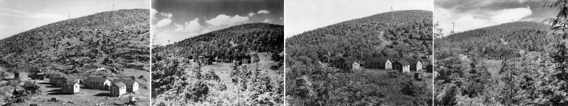
“Douglas Fir Regrowth at Weyerhaeuser Tree Farm” is a series of photos taken at five-year intervals from 1940-1965 at Wolf Point, in the St. Helens area of Washington. This area saw robust growth after being written off by the Department of the Interior as an example of poor forestry practice. Photo credit: Forest History Society, photographer unknown.
Based in Durham, North Carolina, FHS is a nonprofit library and archive dedicated to collecting, preserving, and disseminating forest and conservation history for all to use. Many repeat photos of forested land exist, but they are scattered in many locations, occur in widely different formats, and are relatively difficult to find. The Repeat Photography Project collects sets of repeat photographs relating to land management and environmental research.
From working forests to wilderness areas, such photographic pairs or sequences can help us understand ecosystem processes, as well as the effects of human and non-human disturbances. They can inform our concepts of sustainability, help us understand the implications of public policy, and assess the results of management decisions.
The Repeat Photography Project is a collaboration between FHS and project partners across the country—including private landowners, conservation groups, national associations, government units, forest-reliant communities, and many others. This centralized database will allow for photos to be searched by subject keyword, location, date, format, and photographer, among many other characteristics. Moreover, the site will present repeat photography sets with contextual information and display individual images at a detailed resolution sufficient for comparison and analysis.
FHS will offer a centralized location on the web for users to access, compare, and interpret them. By providing an authoritative site on the subject we hope to identify previously unknown repeat photographic pairs and sequences, promote the creation of new repeat sets, and foster interest in the future uses of repeat photography.
Users—including students, teachers, landowners, and journalists—will improve their understanding of landscape change, sustainability, and working forests. Foresters, natural resources managers, landowners, and conservation groups will be able to point to specific pairs and landscapes of interest, thereby assisting their own training and communication with the public. There will also be many opportunities to utilize the photographs in K-12 and higher education programs, including those like Project Learning Tree.
So far, FHS has collaborated with the U.S. Geological Survey’s Northern Rocky Mountain Science Center, which has used repeat photography to document the effects of climate change at Glacier National Park; the University of Arizona and their collection of repeat photographs of the Santa Rita Experimental Range; and the Bureau of Land Management’s collection of photographs from their “Historical Comparison Photography” book series featuring sequences from three different sites in Montana.
The leaders of the Repeat Photography Project welcome insights, recommendations, and collaboration in making this valuable historical information more widely available. If you have photos, research ideas, or any other input, please contact project photo archivist Sara Pezzoni.