

Militarizing Memory at International Boundary Marker #1
07 October 2020 – Marla Miller and Sarah A. Leavitt
preservation, memory, commemoration series, sense of place, environment, government, human rights, politics
The Rio Grande slows to a trickle as it turns north. It’s hardly a picturesque spot, here on the banks of one of the continent’s longest rivers. The scrub is sporadic, the trees are low, and heavily armed security forces from two nations watch you closely. The river is heavily dammed as it separates Texas and New Mexico in the U.S., and Chihuahua, Mexico; the view in any direction encompasses water management infrastructure, office trailers, the aforementioned trickle running between graffitied banks of concrete, and—along an eastern slope of Mount Cristo Rey—a 20-foot tall steel border wall. And in the midst of all of this sits International Boundary Marker #1.
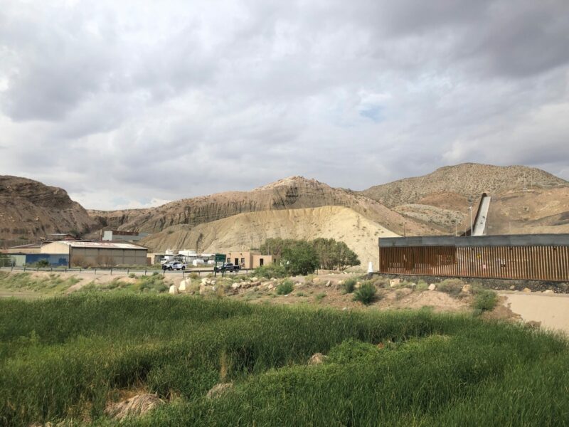
Boundary Marker #1 in the shadow of the 2019 border wall, Sunland Park, New Mexico. Photo credit: Marla Miller and Sarah A. Leavitt
If you were not looking for the marker, placed on January 31st, 1855, you’d never find it. Part of what was once the only infrastructure marking the U.S.-Mexico border, today it is almost literally impossible to visit even if you have traveled across the country specifically in its pursuit. In 1889, the International Boundary Commission (now the International Boundary and Water Commission (IBWC) took over management of the boundary marker program. According to its website, the mission of the IBWC—a government agency managed by parallel offices in El Paso and Juárez—is “to provide binational solutions to issues that arise during the application of United States-Mexico treaties regarding boundary demarcation, national ownership of waters, sanitation, water quality, and flood control in the border region. Officially, the IBWC grants U.S. citizens access to this boundary marker, which now sits on land adjacent to an IBWC diversion dam some 140 feet from the border. A commemoration, of sorts, of the end of the U.S.-Mexican War (1846-48), the marker is a reminder that this place was, and remains, contested land.[1]
As public historians contemplating border infrastructure, we picked this monument as an apt place to start our border history research trip. We were working toward an exhibit, The Wall/El Muro: What is a Border Wall? set to open in Washington, D.C., in May 2020. Of course, due to the COVID-19 pandemic, the exhibition has been postponed. But as we wait to see if the exhibition can yet open, we can think about the layering of historical commemoration at this one spot where the oldest border marker and the brand-new border wall meet in an uneasy stalemate.
Boundary Marker #1 was not an easy place to begin our journey because it is not an easy place to find. Dirt roads, interstate overpasses, an international border, and an amusement park collide in the El Paso suburb of Sunland Park, New Mexico, creating a cluster of strip malls just like any other, a water-regulation infrastructure project with international ramifications for the water supply, and the location of what has been a popular crossing place for migrants fleeing whatever terrible problems have made this potentially deadly journey seem like the only answer they have left. And here we were, white historians in a white rental car, driving in circles under the watchful eye of the ever-present green-striped vehicles of our own nation’s border patrol.
Marker #1, one of 258 nineteenth-century monuments marking the land border between the U.S. and Mexico, sits south of the Rio Grande, and therefore is, for all practical purposes, in Mexico. In fact, today many of these markers are now south of border fencing and are even less accessible than this one. The IBWC is not in the memory business, so it is not surprising that their staff seemed entirely uninterested in our effort to access the marker. We worked the phones to no avail, got a little lost and a little scared, and finally gave up until a few days later. By then, we had spent time with lawyers and migrants at an El Paso detention center and across the bridge in Juárez learning more about the border crisis. On our way out of town, we appeared at the door of the IBWC offices and, as a last-ditch effort to see the site of the first border infrastructure, begged for access to the marker.
When we visited, just weeks after the mass shooting at the El Paso Walmart and in the midst of a national conversation about asylum seekers, migrant caravans, and family separation, the state of the border was grim. Boundary Marker #1 was “protected” by Mexican police sitting in the shade nearby (watching for potential river crossers, of course, and not actually that worried about the monument, which presumably receives little daily attention). Meanwhile, IBWC officers chaperoned us to the site, under the constant surveillance of the U.S. Customs and Border Patrol agents who sat atop a nearby mountain.
But it was not always that way. Not so long ago, this area looked very different. In the 1970s local groups (a range of U.S. and Mexican organizations, from the Juárez Committee of the Chihuahua Historical Society and the Federal Board of Material Improvements of Juárez, Mexico, to the the El Paso County Historical Society, the Beautify El Paso Association, the Dona Ana County Historical Society, and the State of New Mexico) collaborated to capitalize on potential tourist-generating interest in the marker by creating an historic site with landscaping and a parking lot to welcome visitors. The site was named to the National Register of Historic Places in 1974, the same year that the Chamizal National Memorial was created. The latter celebrates the peaceful resolution of a longstanding boundary dispute, which included the intensive management of the Rio Grande course in a permanent, concrete channel. Sitting further east along the river, Chamizal, too, encompasses a boundary marker, this one readily accessible to visitors on the U.S. side. Shortly thereafter (in 1976, in “Bicentennial recognition”) the American Society of Civil Engineers named the marker a Historic Civil Engineering Landmark. The designation lauds the “superb surveying skills of William Emory and the Emory-Salazar Commission that pinpointed the exact boundary between the U.S. and Mexico across some 2,000 miles of uncharted territory.”
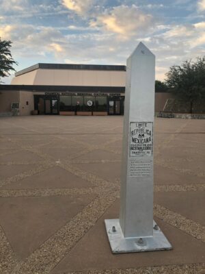
Chamizal National Memorial, El Paso, Texas. Photo credit: Marla Miller and Sarah A. Leavitt
Such efforts, we propose, helped convert marker to monument. Put another way, by 1980, in the context of the landmark designations and the NPS site, the 1855 marker had assumed new meanings. Installed to function ostensibly as a geopolitical marker and an expression of conquest, the white obelisk had gradually taken on new valences as a historic site. On the Mexican side, Madero Park became the grounds for an historic house museum, the Casa de Adobe, constructed in 2011 to interpret histories of the Mexican Revolution. On both sides of the border, the area was designed to be a calm reminder of long-past conflict, now resolved.
But by 2019, that sense of international cooperation had dissipated. If the monument was intended to foster a sense of order, it has ceased to serve that purpose. In its new setting in the shadow of the Trump-era border wall project, it no longer functions as a historic marker of a largely forgotten war. The site does not welcomes tourists now: to be sure, there is no longer anything park-like about the site. The obelisk faced with white marbleized concrete is lost amid the more serviceable concrete container of the river. When we visited the marker, the Adobe House was closed. We had to be escorted by government officials, surrounded by heavily armed officers of two nations, beneath crowdsourced steel bollards. If anything, the site now commemorates the failure of decades of immigration policy, the desperation of migrants who attempt the crossing nearby, despite aggressive policing. Meanwhile the trickle of a once-mighty river at this site reminds us that our water policies and diversions have fundamentally altered nature as well.
We did get to see the boundary marker that day. We stood and posed for photos in front of it, just as the surveyors themselves did when they installed the markers more than a century and a half ago.
Those surveyors would not recognize the area as it looks today, though to observe the concrete channel that was once a river, or to note the juxtaposition of the white obelisk with the steel-columned border wall that snakes up the hill behind it, hardly takes subtle analysis. As two nations patrol this site with guns and intimidation, the engineering monument fades into the background. We have, in 165 years, gone from marking the border to policing the border, from commemorating the end of a violent war to militarizing the very emblem of that brokered peace.
~Marla Miller, the NCPH immediate past president, directs the Public History program at UMass Amherst, where she consults with a range of museums and historic sites.
~Sarah A. Leavitt is a museum curator and public historian; most recently she worked at the National Building Museum, where her exhibitions included Evicted and Architecture of an Asylum.
[1] On the larger history of the memory of this conflict on both sides of the border, see Michael Scott Van Wagenen, Remembering the Forgotten War: The Enduring Legacies of the U.S.-Mexican War (Amherst: University of Massachusetts Press, 2012).